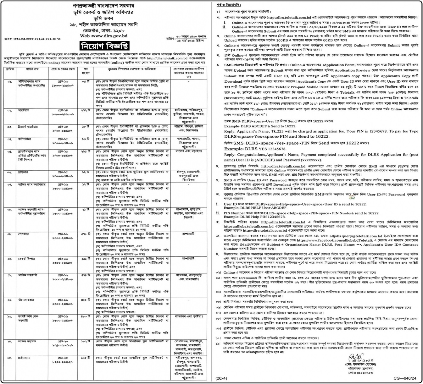
Directorate of Land Records and Surveys
ভূমি রেকর্ড ও জরিপ অধিদপ্তর
Job Category: Govt. Job
Job Source: The New Age
Posted On: 16 Mar 2024
Application Deadline:30 Apr 2024
Web: www.dirs.gov.bd
Apply
Welcome to our website bangladeshtodays.org. This is the best website online. Here you will get daily updates on all types of job news such as: E.g Job Vacancies in Public Sector, Private Sector, Corporate, Banking, NGO Jobs etc. You can select any type of job from the category option in the top menu of the website. You can apply for jobs directly on our website. There is a search option at the top of this website where you can search for jobs according to your requirements. If you have benefited even in the slightest from our website, then you can tell your friends, family and everyone else about this website. I hope you also benefit from this website. You can share this website post on Facebook, Instagram, Twitter or any other online platform if you want. Many people can benefit from your sharing. And if there is anything you want to know or understand, you can contact us by email on the contact page of this website. We will try our best to help you, thank you very much.
Directorate General of Land Records and Surveys (DLRS) is a government agency in Bangladesh responsible for maintaining accurate records of land ownership, conducting land surveys, and providing land-related services to citizens, businesses, and government agencies. DLRS was established to streamline land administration and ensure transparency in land transactions. It plays an important role in facilitating land-related transactions, resolving disputes and promoting sustainable land management practices. **History and Establishment:** The origins of the Directorate of Land Records and Surveys date back to the colonial period when British administrators introduced a systematic land surveying and recording system in the Indian subcontinent. After Bangladesh’s independence in 1971, the newly established government recognized the need to modernize land administration and establish a central authority to effectively manage land recording and surveying. In 1972, the Government of Bangladesh established the Directorate General of Land Records and Surveying of the Ministry of Lands, which was tasked with overseeing land administration, cadastral mapping, and surveying activities throughout the country. Since its inception, DLRS has undertaken several reform and modernization efforts to improve efficiency, accuracy, and service delivery standards. **Mission and Goals:** The mission of the Directorate General of Land Records and Surveys is to ensure accurate, transparent and accessible land administration services for all stakeholders, promote security of land tenure, facilitate land transactions and promote sustainable land management. It’s about supporting practices. The main purposes of DLRS are: 1. **Maintaining land records:** Systematically collecting, updating, and digitizing cadastral maps, cadastres, and other land-related documents to ensure up-to-date information on land ownership, title, boundaries, and transactions. and maintain reliable records. 2. **Performing Surveys:** Performing land surveying, cadastral mapping, and geospatial data collection activities to accurately delineate properties, establish property boundaries, and support land registration and title processes. To do. 3. **Facilitate Land Transactions:** Facilitate land transactions, transfers, leases, and mortgages by providing land-related information, verification services, and legal documents to landowners, buyers, sellers, and financial institutions. 4. **Land Dispute Resolution:** Mediation, arbitration, and legal means to ensure fair and timely resolution of disputes to prevent social unrest and promote security of land tenure. Resolve land disputes, boundary disputes, and encroachment issues through 5. **Promoting land management:** Promoting environmental protection efforts, including sustainable land management practices, land use planning, land reclamation, soil conservation, watershed management, and forest conservation. **Organizational structure:** The Directorate General of Land Records and Surveys operates under the Ministry of Lands and is headed by a government-appointed director. The DLRS is divided into several divisions, divisions, and field offices that are responsible for performing specific functions and tasks related to land management and surveying. The DLRS organizational structure includes: 1. **Administration:** Responsible for general administrative and administrative functions, including human resources management, budgeting, procurement, and coordination with other government agencies and stakeholders. 2. **Land Records Department:** Manages land records, cadastral maps, and land records, including maintenance of land records, variation records, and ownership documents. 3. **Surveying and Mapping Department:** Land surveying, cadastral mapping, and geospatial data collection activities using the latest surveying techniques, GPS technology, and remote sensing tools to update cadastral maps and real estate records. will be carried out. 4. **Legal Department:** Provides legal advice, interpretation and assistance regarding land laws, regulations and procedures, including land dispute resolution, litigation support and legal documentation services. 5. **Information Technology Department:** Develops and maintains land information systems, databases, and online platforms for accessing land-related information, records, and services, thereby improving transparency, efficiency, and access to land management processes. improve ease of use. 6. **Training and Development Division:** Provides training, development and professional development programs for DLRS staff, surveyors, land managers and stakeholders to improve their skills, knowledge and abilities in land management and surveying. Offers. **Features and Services:** The Directorate General of Land Records and Surveys provides a wide range of functions and services to meet the land-related needs of citizens, businesses, and government agencies. The most important features and services of DLRS include: 1. **Land Registration and Title:** Facilitates the registration and vesting of land and property rights, including the issuance of land titles, deeds and certificates to landowners and residents. 2. **Changes and Transfers:** Processes applications for land parcel changes, transfers, divisions, and amalgamations, and updates land records and ownership details based on changes in land ownership and transactions. 3. **Cadastral Mapping:** Carry out cadastral surveys and mapping activities to delineate land boundaries, establish property boundaries, and create cadastral maps for land registration and tax purposes. 4. **Land Information Services:** Provides land-related information, records, and documents to landowners, buyers, sellers, and interested parties through information centers, online portals, and public access points. 5. **Real estate valuation and valuation:** Evaluation of the value of land and real estate for tax, assessment and compensation purposes, including the determination of real estate income, real estate taxes and real estate acquisition rates. 6. **Land Records Verification:** Verification of land titles, deeds and land records for legal, financial and administrative purposes, such as conducting due diligence checks and issuing land title deeds. 7. **Land Dispute Resolution:** Mediation, arbitration and resolution of land disputes, disputes and grievances through alternative dispute resolution mechanisms including mediation, arbitration and litigation. 8. **Land Use Planning:** Partner with local government authorities to participate in land use planning, zoning, and development control activities to regulate land use, urban growth, and environmental protection. **Modernization and digitalization initiatives:** In recent years, the Directorate General of Land Records and Surveys has undertaken various modernization and digitization initiatives to improve the efficiency, accuracy and transparency of land administration processes. Major initiatives include: 1. **Land Records Digitization:** Digitize land records, cadastral maps, and title documents to create electronic databases, archives, and information systems to store, search, and manage real estate-related information online. 2. **Online Land Services:** The introduction of online platforms, portals and mobile applications that provide land-related services such as land registration.